Der beste Wetterbericht im Bezug auf tropische Stürme liefern die Amerikaner. Sie haben das größte Interesse, denn die Stürme richten auf amerikanischen Boden statistisch den größten Schaden an. Auf der Webseite des „National Hurricane Center“ gibt es die Wetter-Berichte regelmäßig aktualisiert zum Download. Ein Verzeichnis mit den reinen Berichten in Textform ist ebenfalls zu finden, was auch den Download über Schmalbandverbindung (Iridium oder Kurzwelle) möglich macht. Relevant sind vor allem die Diskussion und der Outlook (nein, nicht das Mailprogramm!).
In der Diskussion werden die Wetterbedingungen und -Entwicklung beschrieben. Das gibt dem Segler mehr und bessere Informationen. Insbesondere Hinweise zu den „tropischen Wellen“ sind hier enthalten. Die bringen meist Regen und Wind und sind bei den passenden Bedingungen die Keimzelle der Stürme.
Der Outlook ist normal eher kurz und knapp, und gibt die Wahrscheinlichkeit für eine Sturmentwicklung in den nächsten 5 Tagen an. Der erste der Saison enthält allerdings allerlei Zusatzinfos:
******Schnipp******
Expires:No;;266468
ABNT20 KNHC 011132
TWOAT

Tropical Weather Outlook
NWS National Hurricane Center Miami FL
800 AM EDT Fri Jun 1 2018

For the North Atlantic...Caribbean Sea and the Gulf of Mexico:

Tropical cyclone formation is not expected during the next 5 days.

Today marks the first day of the Atlantic hurricane season, which
will run until November 30. Long-term averages for the number of
named storms, hurricanes, and major hurricanes are 12, 6, and 3,
respectively.

The list of names for 2018 is as follows:

Name Pronunciation Name Pronunciation
-------------------------------------------------------------
Alberto al-BAIR-toe Leslie LEHZ-lee
Beryl BEHR-ril Michael MY-kuhl
Chris kris Nadine nay-DEEN
Debby DEH-bee Oscar AHS-kur
Ernesto er-NES-toh Patty PAT-ee
Florence FLOOR-ence Rafael rah-fah-ELL
Gordon GOR-duhn Sara SAIR-uh
Helene heh-LEEN Tony TOH-nee
Isaac EYE-zik Valerie VAH-lur-ee
Joyce joyss William WILL-yum
Kirk kurk

One named cyclone, Alberto, already formed this year in May. The
next named storm that forms this season will be called Beryl.

This product, the Tropical Weather Outlook, briefly describes
significant areas of disturbed weather and their potential for
tropical cyclone formation during the next five days. The
issuance times of this product are 2 AM, 8 AM, 2 PM, and
8 PM EDT. After the change to standard time in November, the
issuance times are 1 AM, 7 AM, 1 PM, and 7 PM EST.

A Special Tropical Weather Outlook will be issued to provide
updates, as necessary, in between the regularly scheduled
issuances of the Tropical Weather Outlook. Special Tropical
Weather Outlooks will be issued under the same WMO and AWIPS
headers as the regular Tropical Weather Outlooks.

A standard package of products, consisting of the tropical cyclone
public advisory, the forecast/advisory, the cyclone discussion,
and a wind speed probability product, is issued every six hours
for all ongoing tropical cyclones. In addition, a special
advisory package may be issued at any time to advise of
significant unexpected changes or to modify watches or warnings.

The National Hurricane Center (NHC) has the option to issue
advisories, watches, and warnings for disturbances that are not yet
a tropical cyclone, but which pose the threat of bringing tropical
storm or hurricane conditions to land areas within 48 hours. For
these land-threatening "potential tropical cyclones", NHC will issue
the full suite of advisory and watch/warning products. Potential
tropical cyclones share the naming conventions currently in
place for tropical depressions, being numbered from a single list
(e.g., "One", "Two", "Three", etc.).

The Tropical Cyclone Update is a brief statement to inform of
significant changes in a tropical cyclone, to post or cancel
watches or warnings, or to provide hourly position updates between
intermediate advisories when the storm center is easily followed
by radar. The Tropical Cyclone Update is also used in lieu of
or to precede the issuance of a special advisory package.
Tropical Cyclone Updates, which can be issued at any time, can
be found under WMO header WTNT61-65 KNHC, and under AWIPS header
MIATCUAT1-5.

All NHC text and graphical products are available on the web at
www.hurricanes.gov. More information NHC text products can be found
at www.hurricanes.gov/aboutnhcprod.shtml, while more information
about NHC graphical products can be found at
www.hurricanes.gov/aboutnhcgraphics.shtml.

You can also interact with NHC on Facebook at
www.facebook.com/NWSNHC. Notifications are available
via Twitter when select NHC products are issued. Information
about our Atlantic Twitter feed is available at
www.hurricanes.gov/twitter.shtml.

$$
Forecaster Cangialosi/HSU
******Schnapp****** <= (c) by TB
So jetzt wissen wir schon mal wie die Stürme in diesen Jahr heißen werden 🙂
Normal sieht es eher so aus:
******Schnipp******
000
ABNT20 KNHC 012303
TWOAT

Tropical Weather Outlook
NWS National Hurricane Center Miami FL
800 PM EDT Fri Jun 1 2018

For the North Atlantic...Caribbean Sea and the Gulf of Mexico:

Tropical cyclone formation is not expected during the next 5 days.

$$ Forecaster Blake
******Schnapp****** <= (c) by TB
Sollte ein Sturm auftreten, sind natürlich die Informationen zum Sturm wie Zugbahn und Entwicklung wichtig. Die Grafik „Tropical Cyclone Marine Danger Graphic“ ist da eine gute und verständliche Zusammenfassung: Sie zeigt die vorrausgesagte Zugbahn des Sturms mit einem Fehlertrichter. Das heißt, je weiter in Zukunft je breiter die mögliche Position des Zentrums.
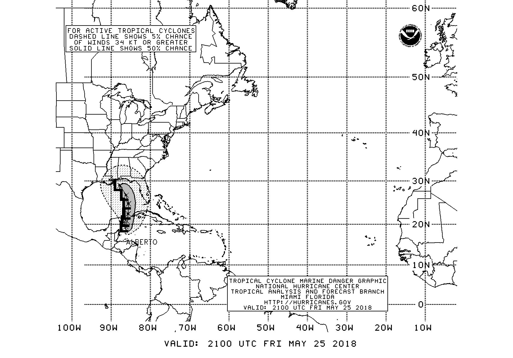
Hier das Beispiel von Alberto, dem ersten Sturm in diesem Jahr.
Bei einer Vorwarnzeit von ca. 2-5 Tagen kann man bei 5 Knoten Fahrt aus dem gröbsten Gefahrenbereich herausfahren. Wenn man abfahrbereit ist …
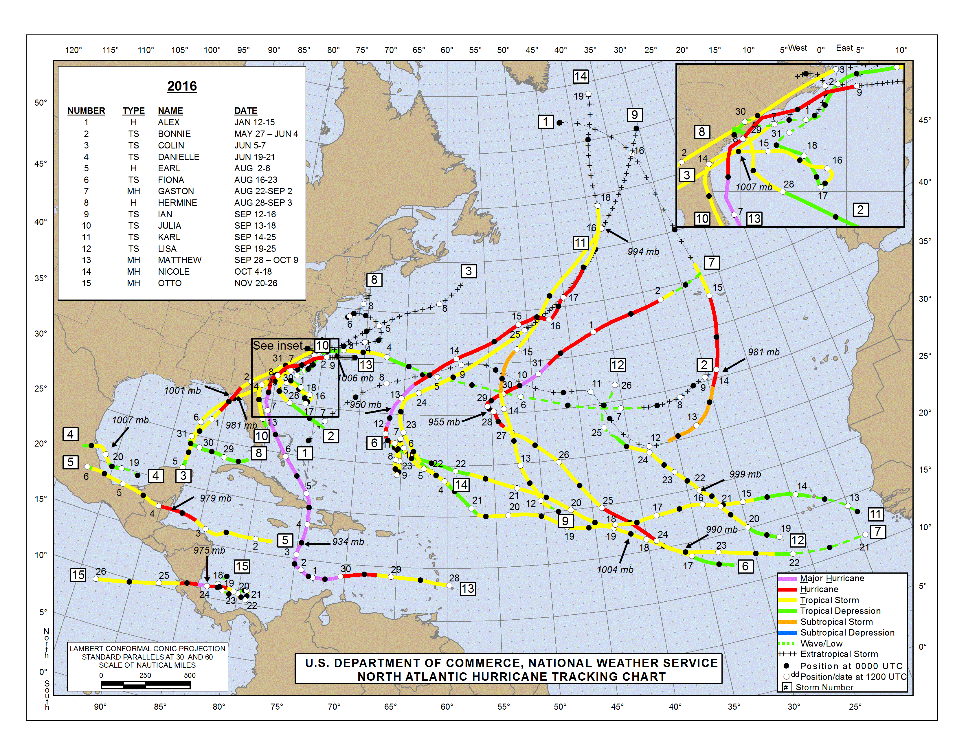
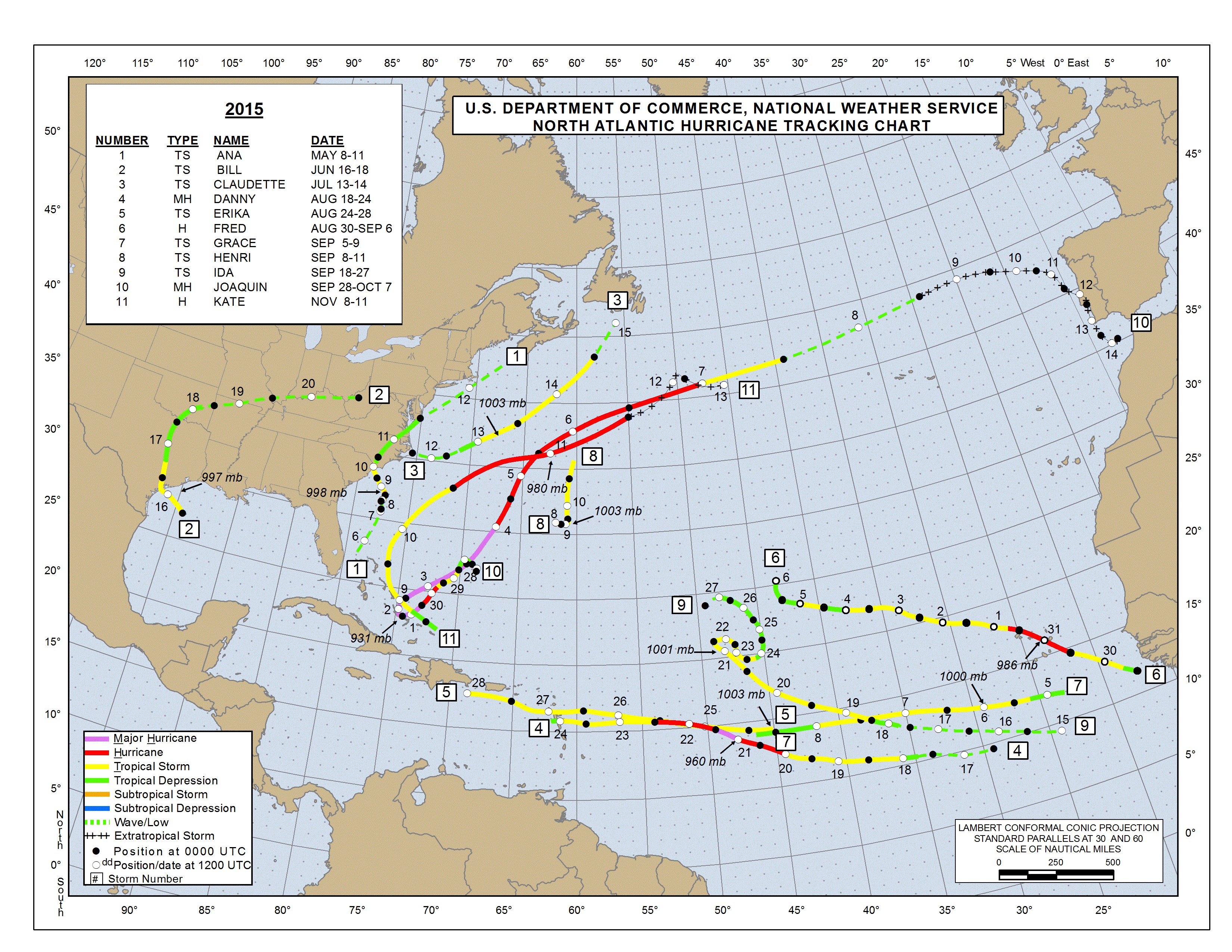
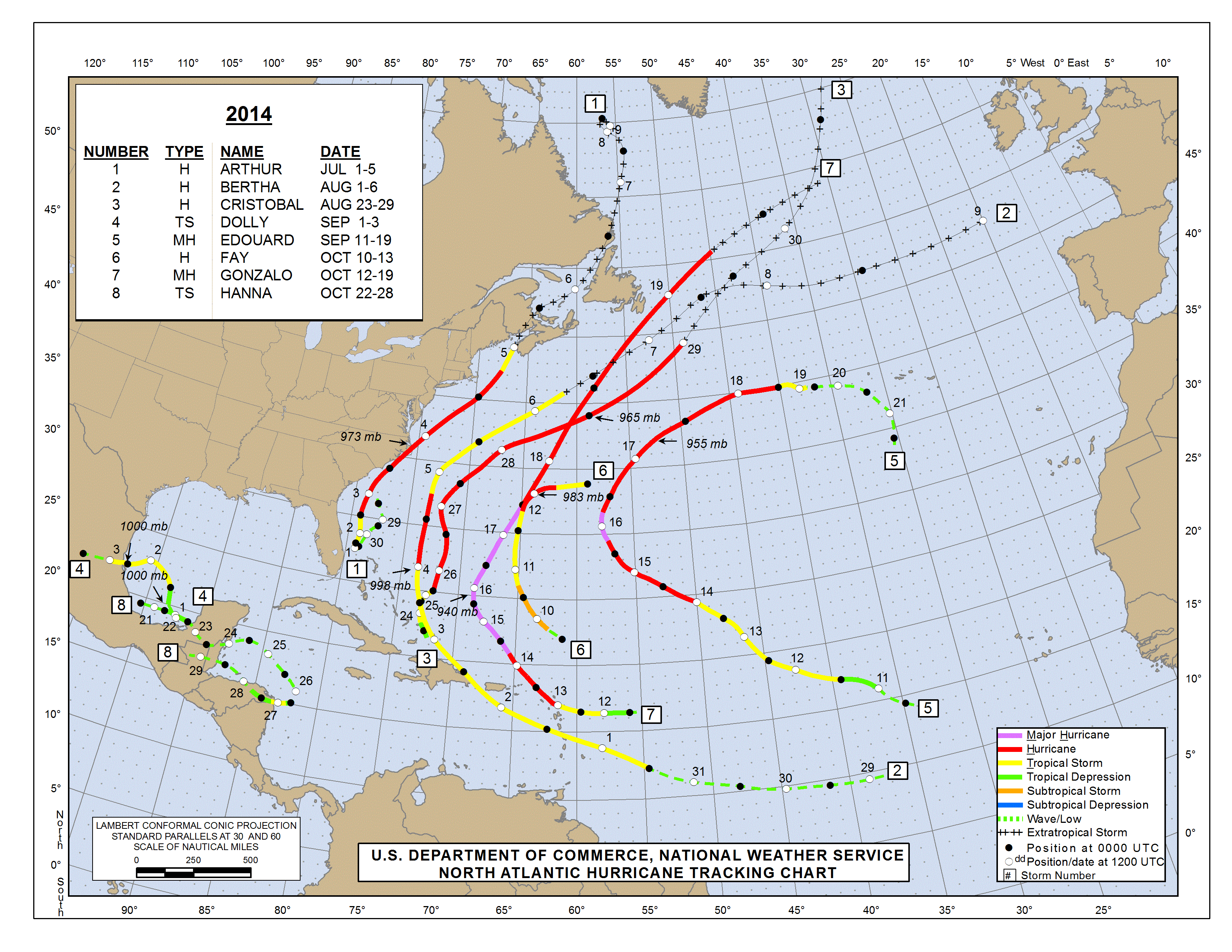
Ebenfalls interessant auf der Seite des NHC sind die veröffentlichten Daten der Vergangenheit wie zum Beispiel die Zugbahnen der Hurricanes der letzen Jahre z.B. 2016, 2015, 2014, …
Wem das alles noch nicht reicht, kann sich Mike’s Weather Page anschauen. (Danke an Laure von Sy-Olena für den Tipp)
Wenn man mit Einheimischen spricht hört man oft: „The only predictable on Hurricanes is that they are unpredictable“ Auch das NHC hat hier so manches dokumentiert z.B.“Wrong Way Lenny“
All die Informationen helfen bei der persönlichen Risikoabschätzung.
Wie bekommt man nun die Dateien an Bord, und zwar egal, ob man nun in Handy und somit Internetreichweite ist oder nicht ? Das folgt in einem anderen Artikel ?.